chongqing neighborhoods
the 8d city, one layer at a time
your map app will lie to you. that's fine.
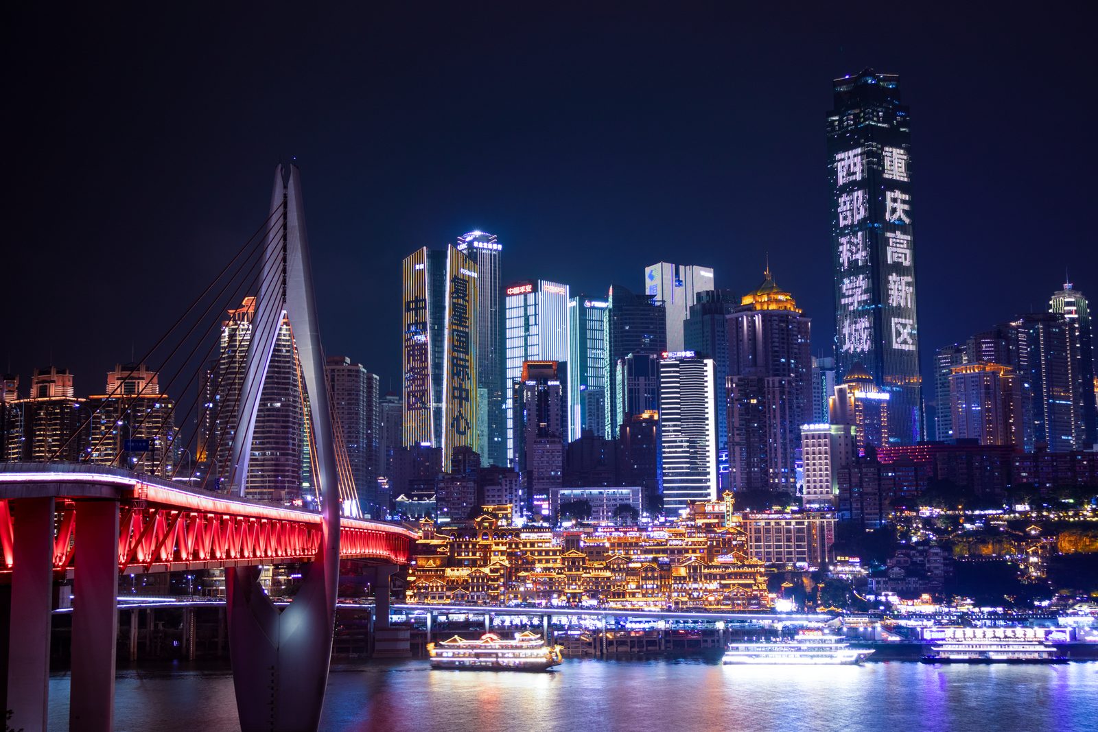
- stay in jiefangbei. hongyadong, shibati, the river and dozens of hotpot spots are all walkable.
- hongyadong is a 2006 reimagining of the stilt houses (diaojiaolou) that used to cling to this cliff. see it from qiansimen bridge after dark.
- liziba is the monorail through the apartment building. pair it with eling erchang, a wartime banknote factory turned art park.
- shibati is the old stairway between the upper and lower city, rebuilt and reopened in 2021.
- ciqikou is a song-era porcelain port on the jialing. go on a weekday morning or don't go.
chongqing doesn’t have neighborhoods so much as layers. you walk out of a mall on the ground floor and you’re on a bridge. you take an elevator down 11 stories and you’re on a street. a monorail goes through an apartment block and the people inside just live there.
the internet calls it the “8d city,” and the nickname is earned. but each layer of chongqing has its own story, and most of those stories are about one thing: a big city squeezed onto a steep rocky peninsula where two rivers meet.
the chongqing neighborhood map
tap a neighborhood. placement is our vibe read, not science.
jiefangbei 解放碑
a wartime clock tower in a canyon of neon
the backstorythe 27.5-meter clock tower at the center has been three monuments in one lifetime. in 1941, during the japanese bombing of the wartime capital, the nationalist government put up a wooden tower called the 'spiritual fortress' to keep morale up. after the war it was rebuilt in concrete (1946–47) as a victory monument, and in 1950 it was renamed the people's liberation monument — jiefangbei — which is the name the whole district now goes by. today it's the bullseye of the yuzhong peninsula: a pedestrian plaza ringed by towers so tall the monument looks like a toy.
you’ll love it iffirst-timers who want everything walkable, shoppers and night-walkers.
- the liberation monumentstand at the base and look up at the towers around it. the contrast is the whole chongqing story in one frame.
- bayi road snack streeta few minutes' walk away, a lane of noodle, dumpling and skewer stalls. graze, don't commit to one meal.
- raffles city + chaotianmenwalk downhill to the tip of the peninsula, where the yangtze and jialing meet. the 'sky bridge' of raffles city hovers overhead.
- chongqing xiaomianthe city's breakfast: wheat noodles in a chili-oil, sichuan-pepper broth. ~$1–2 at any hole-in-the-wall.
- suanla fen (hot and sour glass noodles)slippery sweet-potato noodles in vinegar and chili, topped with peanuts. cheap, sour, addictive.
hongyadong 洪崖洞
eleven floors of glowing stilt houses glued to a cliff
the backstorywhen the ming general dai ding walled chongqing in 1371, hongya gate was one of the city's 17 gates, and the cliff below it became a dock and warehouse district. riverside families built diaojiaolou — wooden stilt houses propped on poles against the slope, the classic solution for a city with no flat ground. by the 2000s the old stilt houses were falling apart and were cleared; the complex you see now, finished in 2006, is a concrete reimagining of that architecture, 11 stories tall, with a street on the top floor that connects to the city above. everyone online says it looks like spirited away. it does.
you’ll love it ifanyone with a camera, and anyone who wants the chongqing that went viral.
- qiansimen bridgesee it first from the bridge just after dark: the whole cliff glowing gold above the jialing river.
- inside hongyadongenter on the top floor from the city side and take the lifts down, floor by floor. it's touristy snacks and souvenirs, but the vertical maze is the attraction.
- the riverside belowcome out at river level and look back up. the street you started on is now 11 stories over your head. welcome to chongqing.
- hotpot with a river viewseveral restaurants on the upper floors face the river. pricier than the backstreets, but the view is the point.
- street skewers + sweet bean jellygrab skewers on the walk down, then a bowl of sweet bingfen (ice jelly) with brown sugar syrup to put the fire out.
ciqikou old town 磁器口
a thousand-year-old porcelain port on the jialing
the backstorya riverside settlement here goes back to the song dynasty. its romantic old name, longyin ('hidden dragon'), comes from a legend that the deposed ming emperor jianwen escaped his burning palace disguised as a monk and hid in the local baolun temple. the current name means 'porcelain port': in the ming and qing it shipped porcelain and goods down the jialing river, and the docks fed a town of teahouses, wooden shops and stone lanes. the main street is a snack-crowd zoo now, but the side alleys climbing the hill still have the old bones.
you’ll love it ifpeople who want a slice of old riverside chongqing and don't mind sharing it with snack crowds.
- the main streetwalk the stone-paved main lane from the gate down to the river: wooden shopfronts, chili stalls, mahua being twisted by hand.
- baolun templeclimb up to the temple tied to the hidden-emperor legend. it's the quietest spot in town.
- the side lanes + riverbankduck into the back alleys for the real old houses, then sit by the jialing with a tea and watch the river.
- chen mahuacrunchy twisted dough sticks in sweet, salty or spicy flavors. the famous ciqikou souvenir, a few dollars a bag.
- mao xue wanga spicy stew of blood curd, tripe and eel. local lore says it was invented in ciqikou by a butcher's family; whether or not, this is the place to order it.
liziba + eling 李子坝 · 鹅岭
a train through an apartment block, a factory turned art park
the backstoryliziba station sits on the 6th to 8th floors of a 19-story residential building on line 2, the monorail that hugs the jialing river; it opened in the mid-2000s, and the 'train eats a building' clip made it famous worldwide years later. up the hill, eling park began as liyuan, a salt merchant's private garden built in 1909, and during the war it hosted foreign diplomatic missions. next door, eling erchang was built in 1939 as the central bank's banknote printing factory for the wartime government, then became chongqing printing factory no. 2; since the mid-2010s it's been a creative park of cafes and studios, made famous by the 2016 film 'i belonged to you'.
you’ll love it ifpeople who came for the viral chongqing and want to see the quieter, greener ridge above it.
- liziba viewing platformwatch a train slide into the building from the free platform below. trains come every few minutes; patience gets you the shot.
- eling erchangclimb up to the old printing factory: brick buildings, rooftop cafes, and a panorama over the peninsula and the river.
- eling parkfinish in the old liyuan garden and climb the tower at the top for one of the best 360° views in the city.
- coffee with a view at erchangthe rooftop cafes charge a bit more (~$4–6) and you're paying for the skyline. worth it at golden hour.
- wanza miannoodles topped with soft yellow peas and crispy minced pork in chili sauce, a chongqing classic. small shops below the ridge do it for ~$1–2.
shibati 十八梯
the stairway between the upper city and the lower
the backstorychongqing's old core was split into an 'upper half-city' on the ridge and a 'lower half-city' by the yangtze docks, and shibati — 'eighteen steps', named for the flights of stairs climbing past a well — was one of the main stairways between them, hauled up by porters and water carriers for centuries. it also holds one of the city's darkest wartime memories: on 5 june 1941, during a japanese air raid, more than a thousand people died of suffocation and crush in the overcrowded shelter tunnel at nearby jiaochangkou. the old shacks were cleared in the 2010s and the area reopened in september 2021 as a rebuilt historic quarter.
you’ll love it ifpeople who want the stair-and-alley chongqing, history lovers, and anyone who wants to understand the city's vertical logic with their own legs.
- the top of the stairs at jiaochangkoustart upstairs and look down the stepped lanes toward the yangtze side. this is the old upper-city edge.
- the eighteen-steps laneswalk down through the rebuilt grey-and-wood terraces, little museums and teahouses. look for the old well and the shelter tunnel entrances in the cliff.
- the lower citycome out in the old lower half-city near the river and grab a snack. then take a taxi back up. no shame.
- hotpot in an old air-raid shelterchongqing turned some of its wartime shelters into restaurants. eating hotpot inside a cool rock tunnel is peak chongqing, and a meal runs ~$15–25 a person.
- hongyou chaoshou (red-oil wontons)wontons drowned in chili oil, ~$2–3. the classic snack to fuel the climb back up.
tap a dot to open each neighborhood: the real history, a perfect three hours in walking order, what to eat, and the nearest metro.
why chongqing looks like this
two rivers, one rock. the old city sits on the yuzhong peninsula, a ridge of rock where the jialing river flows into the yangtze at chaotianmen. no flat land, river traffic on both sides. for centuries the city’s wealth came up from the docks, and the only way up was stairs.
the people who carried the city. those stairs created a job: the bang bang men, porters who carried loads up and down the hills on a bamboo pole (the bang bang) and some rope. at their peak in the reform era there were hundreds of thousands of them by most estimates; delivery apps, roads and elevators have shrunk that to a small, aging crew. if you see one, that’s living history walking past you.
stilt houses. with no flat ground, riverside chongqing built diaojiaolou — wooden stilt houses propped on poles against the slope, sometimes many levels tall. that’s the architecture hongyadong reimagines today, in concrete and neon.
the wartime capital. when japan invaded eastern china, the nationalist government retreated up the yangtze and made chongqing its wartime capital from late 1937 until 1946. from 1938 to 1943 the city was bombed again and again in one of the longest air campaigns of the war. chongqing’s answer was to go underground: it dug air-raid shelters and tunnels into the soft rock everywhere. those shelters are still there, and some are now warehouses, shops — and hotpot restaurants, where you eat in a cool rock tunnel that once kept people alive.
where to stay in chongqing: jiefangbei vs hongyadong vs nan’an
jiefangbei is the easy answer. the liberation monument sits at the center of the yuzhong peninsula, and hongyadong, shibati, the yangtze cable car and chaotianmen are all walkable. lines 1, 2 and 6 are a few minutes away. the monument itself is a great story: a wooden morale tower in 1941, rebuilt as a victory monument in 1947, renamed for the 1949 liberation in 1950.
hongyadong works if you want to wake up to the river, but sleep on the yuzhong side nearby rather than in the complex itself — it’s loud until late.
nan’an (the south bank across the yangtze) is the pick for a hotel room with the whole skyline in the window. you’ll take more taxis, but the view is unreal.
| neighborhood | old ↔ new | sleepy ↔ chaotic | go for |
|---|---|---|---|
| jiefangbei | brand new | chaotic | neon, shopping, base camp |
| hongyadong | rebuilt 2006 | chaotic | the night view |
| ciqikou | ancient | busy | old riverside town, snacks |
| liziba + eling | mid-century | fairly calm | the monorail, art park, views |
| shibati | old bones, rebuilt | medium | stairs, wartime history |
hongyadong: the stilt houses, reimagined
when the ming general dai ding walled chongqing in 1371, hongya gate was one of the city’s gates, and the cliff below it became docks and stilt houses. by the 2000s those houses were falling down and were cleared; the 11-story complex that opened in 2006 is a tribute rather than a survivor.
it’s still the most chongqing thing in chongqing. enter from the city on the top floor, ride the lifts down and come out at the river with the “street” you started on now high above you.
liziba and eling: the viral layer and the quiet one
liziba station sits on the 6th to 8th floors of a 19-story residential building. line 2 runs through it every few minutes, and there’s a free viewing platform at the bottom where everyone waits for the money shot. it opened in the mid-2000s and became world-famous years later on short-video apps.
most people take the photo and leave. don’t. climb the hill to eling erchang, built in 1939 as the wartime central bank’s banknote printing works, later a state printing factory, and now a creative park full of rooftop cafes. then finish in eling park, which started life in 1909 as a salt merchant’s private garden and hosted foreign diplomats during the war. the view from the top takes in both rivers at once.
shibati: the stairs between two cities
old chongqing was split into an upper half-city on the ridge and a lower half-city by the yangtze docks. shibati, “eighteen steps,” was one of the main stairways between them. it carries one of the city’s heaviest memories: on 5 june 1941, during an air raid, more than a thousand people died in the overcrowded shelter tunnel at nearby jiaochangkou. the area was rebuilt and reopened in 2021; walk it slowly, from top to bottom, and you’ll feel how the city was stitched together by legs.
ciqikou: the porcelain port
ciqikou goes back to the song dynasty and takes its name from the porcelain it shipped down the jialing. its old name, longyin (“hidden dragon”), comes from a legend that the deposed ming emperor jianwen hid here disguised as a monk. the main street is a weekend crush of twisted mahua and chili stalls, so go on a weekday morning, climb to baolun temple, and get lost in the side lanes.
a two-day chongqing neighborhood plan
- day 1: jiefangbei and xiaomian for breakfast (more on it in the china noodle atlas), shibati in the afternoon, the yangtze cable car to nan’an, hongyadong from qiansimen bridge after dark, hotpot in an old shelter.
- day 2: ciqikou in the morning, line 1 and line 2 to liziba, eling erchang and eling park at golden hour.
for the full city survival kit (airport, didi pickups, getting un-lost), read the chongqing guide. my week of eating hotpot every single night is here. coming from chengdu? it’s about an hour by high-speed train (booking how-to in the china train guide) — see how they compare and chengdu’s neighborhoods.
the vibe check
chongqing is a city you read vertically. jiefangbei is the neon top layer, hongyadong is the stilt houses reborn, shibati is the stairs that held it together, liziba is the future going through someone’s living room, and ciqikou is the river port where it all started. stay in jiefangbei, walk until your legs give up, and say thanks to the bang bang men who did it with a bamboo pole on one shoulder.
the kit for this trip
heads up: some links above are affiliate links. if you book through them we earn a small commission at no extra cost to you — it keeps this guide free. more on that.