the central axis
7.8 km, 700 years, one straight line
do it over two mornings. your calves will thank you.
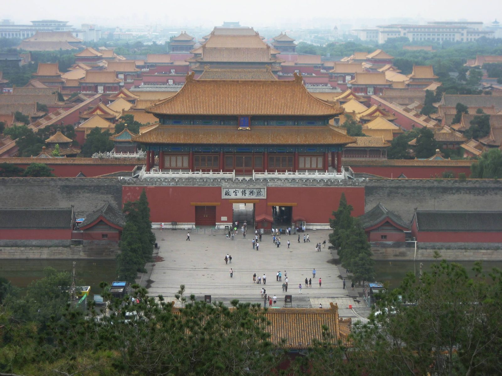
- beijing's central axis is a 7.8 km north–south line from yongdingmen gate to the bell tower, unesco world heritage since july 2024.
- it was first laid out for kublai khan's capital in the 1260s–70s, rebuilt by the ming yongle emperor around 1420, and tweaked by the qing and the 20th century.
- the plan follows an old ideal from the 'kaogongji' text: symmetry, the ruler at the center facing south, ancestors on the left, the gods of soil and grain on the right.
- walk it south → north over a day or two. the forbidden city, tiananmen and the square all need advance booking with your passport.
most cities grow. old beijing was designed, and the design hangs on a single line.
run your finger straight up a map of the city center: a gate in the south, two great altars on either side, the old front gate of the city, a huge square, the gate of heavenly peace, the whole forbidden city, an artificial hill, a 700-year-old bridge, and finally the drum and bell towers. that’s beijing’s central axis, 7.8 km long, listed by unesco in 2024 as “a building ensemble exhibiting the ideal order of the chinese capital.” honestly the most nerd-satisfying walk in china.
here it is, stop by stop, south to north, the way an envoy approaching the emperor would have walked it.
the walk, gate by gate
- 1553 · rebuilt 2004ming (jiajing) · modern rebuild
yongdingmen 永定门
the axis starts at a gate that is, technically, younger than your parents. the original went up in 1553, when the jiajing emperor walled in beijing's southern suburbs as an 'outer city' and made this the main southern entrance, the 'gate of eternal stability'. it was torn down in 1957 for traffic, along with most of beijing's walls. in 2004 the gate tower was rebuilt from old surveys (the barbican and arrow tower were not), partly so the axis would have a proper front door again, and the rebuild became one of the arguments for the 2024 unesco listing.
look for → stand on the plaza north of the gate and look up the long, dead-straight boulevard: on a clear day you're looking straight up the line toward qianmen, 3 km away. that line-of-sight is the whole point.
the park and plaza are free and open all day; the gate tower itself isn't a regular climbable attraction. metro: tianqiao (just north) or yongdingmenwai (just south), both on line 8, each a 10–15 min walk.
photo: rheins · CC BY 3.0 - 1420ming (yongle)
temple of heaven + xiannongtan 天坛 · 先农坛
walking north, the axis passes between two walled altars that mirror each other: the temple of heaven to the east, and xiannongtan, the altar of agriculture, to the west. both were laid out under the yongle emperor and finished in 1420, the same year as the forbidden city. at the temple of heaven the emperor, as 'son of heaven', prayed for good harvests and reported to heaven at the winter solstice; at xiannongtan he ploughed a ceremonial furrow in spring to show he was the empire's first farmer. the round-roofed hall of prayer for good harvests you see today is actually a rebuild: the original burned after a lightning strike in 1889 and was reconstructed within a few years.
look for → the geometry is cosmology: round shapes for heaven, square for earth. the temple of heaven's outer wall is rounded at the north end and square at the south. and count the hall's three tiers of deep-blue tiles, the color of the sky.
temple of heaven: combo ticket ~$5 (apr–oct) / ~$4 (nov–mar), park opens early and the halls close late afternoon; book on the official wechat mini-program or at the gate with a passport. xiannongtan now houses the beijing ancient architecture museum, ~$2, usually closed mondays.
photo: xiquinhosilva · CC BY 2.0 - 1419ming (yongle) · rebuilt 1900s
qianmen (zhengyangmen) 正阳门 · 前门
zhengyangmen, the 'gate facing the sun', was the main southern gate of the ming inner city, finished in 1419. it's actually two buildings: the gate tower to the north and the arrow tower (jianlou) to the south, once joined by a walled barbican so attackers who broke through one gate were trapped in a courtyard. the complex was badly damaged during the boxer uprising of 1900, and around 1915 the barbican walls were removed to make way for traffic and the arrow tower was remodelled by a german architect, which is why it has those slightly european white window arches. at roughly 42 m, the gate tower is the tallest of beijing's surviving city gates.
look for → the white semicircular 'eyebrows' over the arrow tower's windows: they're the 1915 remodel, a strange little east-west handshake on a ming fortress. then turn south and look down qianmen street, the old commercial strip just outside the gate.
the gate tower reopened to visitors in july 2026: ~$3, tue–sun 9:00–17:00, book ahead on the beijing central axis heritage protection center's wechat account (tickets drop daily at 17:00). entry is via the tiananmen square security check. metro: qianmen (line 2).
photo: Andrzej Otrębski · CC BY-SA 4.0 - 1958–1977modern (prc)
tiananmen square 天安门广场
in the ming and qing this was not an open square at all but a narrow, walled t-shaped court called the 'thousand-step corridor', lined with government ministries and closed at its south end by a ceremonial gate (the daming men, later daqing men, then zhonghua men). that gate was demolished in the 1950s, and in 1958–59 the space was cleared and enlarged into one of the biggest public squares on earth, with the great hall of the people on the west side and what's now the national museum on the east. the monument to the people's heroes was completed in 1958 and the mausoleum of mao zedong in 1977, both placed squarely on the axis line. unesco listed the whole square ensemble as one of the axis's components.
look for → notice that even the 20th-century buildings obey the 600-year-old rules: the monument and mausoleum sit dead on the axis, and the great hall and national museum face each other across it like a symmetrical pair of wings.
free, but you must reserve a time slot in advance on the official wechat mini-program with your passport, then pass security. expect bag checks and queues; go early. metro: tiananmen east/west (line 1), qianmen (line 2).
photo: Daniel Case · CC BY-SA 3.0 - 1420 · rebuilt 1651ming (yongle) · qing
tiananmen (gate of heavenly peace) 天安门
this was the front gate of the imperial city, the walled zone of offices, temples and gardens wrapped around the forbidden city. it opened in 1420 as chengtianmen, 'gate of receiving heaven', burned and was rebuilt more than once, and got its current name when the qing rebuilt it in 1651. imperial edicts were read from the top and lowered to officials below. the structure you see today is a careful full-scale rebuild from 1969–70, made to match the old one. it sits on the axis exactly the way the zhou-dynasty planning ideal asks: the ruler's seat faces south.
look for → the five arched doorways: the widest, central one was the emperor's alone. in front, the five white marble jinshui bridges cross the moat, and the carved columns (huabiao) on either side date back to the ming.
climbing the gate tower is ~$2, tue–sun, booked up to 7 days ahead (online reservation opens 17:00 daily) with the passport you'll bring. you also need a square reservation to get here from the south.
photo: Gary Todd from Xinzheng, China · CC0 - 1406–1420ming (yongle) · qing
duanmen → the forbidden city 端门 · 故宫
after the courtyard of duanmen (once a storehouse for imperial ceremonial gear) comes the meridian gate, wumen, and then the palace itself: about 72 hectares, roughly 960 m north to south, built 1406–1420 when the yongle emperor moved his capital from nanjing. the axis runs straight through the three great halls of the outer court, the halls of supreme, central and preserving harmony, raised on a three-tier marble terrace, then through the inner court where emperors actually lived. 24 emperors of the ming and qing ruled from here until 1912. the hall of supreme harmony you see is a 1690s rebuild after fire, which is a theme: wooden palaces burn.
look for → in the main courtyards, nothing is allowed to grow: no trees, no shade, just stone, so the hall towers over you. and stand in the exact center line and look north: everything left of you is mirrored on the right.
~$8.50 (apr–oct) / ~$5.50 (nov–mar), closed mondays. no tickets at the gate: book on the official palace museum site or wechat mini-program, released 7 days ahead at 20:00 beijing time, with the passport you'll bring. sells out in summer and holidays. entry is south (meridian gate) only, exit north at shenwumen.
photo: Balon Greyjoy · CC0 - 1420s · pavilions 1750ming (yongle) · qing (qianlong)
jingshan park 景山
you leave the palace through shenwumen, the 'gate of divine prowess' (it was xuanwumen in the ming, renamed under the kangxi emperor because 'xuan' was in his personal name and became taboo). straight across the road is a hill made by hand: earth dug out for the palace moat was piled here, on top of the site of the old yuan palace, giving the palace a protective hill to its north, as fengshui recommends. in 1644, as rebels broke into beijing, the last ming emperor, chongzhen, hanged himself on its eastern slope. around 1750 the qianlong emperor crowned the ridge with five pavilions; the middle one, wanchun ting, sits on the highest point of the axis.
look for → climb to wanchun ting and turn south: the whole forbidden city is laid out below you in gold roofs, and you can see the axis run straight through it toward tiananmen. turn north and you'll spot the drum tower at the far end.
~$0.30 (yes, really), open early morning to evening; pay at the gate (bring your passport). come at sunset, and on a smoggy day skip it.
photo: N509FZ · CC BY-SA 4.0 - 1285yuan (kublai khan)
wanning bridge 万宁桥
the oldest thing still doing its job on the axis. built in 1285 under kublai khan's yuan dynasty, first in wood and then as a single white-marble arch, it carried the axis road over the channel feeding the lakes at shichahai. it was also a sluice: after the engineer guo shoujing's canal works of the early 1290s, grain barges from the grand canal could sail into the heart of the capital and dock at jishuitan, just upstream. just south of here stood di'anmen, the imperial city's back gate, demolished in 1954–55.
look for → lean over the railing and find the stone 'water-calming beasts' (zhenshui shou) on the banks, some of them yuan-era: scaly, horned, dragon-ish guardians that were meant to keep floods in check. cars still drive over a 700-year-old bridge.
free, always open; it's a normal street bridge on di'anmen outer street. metro: shichahai (line 8).
photo: EditQ · CC BY-SA 4.0 - 1272 · rebuilt 1420yuan · ming (yongle)
the drum tower 鼓楼
kublai khan's planners put a drum tower near here in 1272 (called the qizheng lou); the yongle emperor rebuilt it a little to the east in 1420, on today's axis. drums told the city the time: they marked the night watches, and their beat signalled when the city gates closed. there were 25 drums in all, one big one for the year and 24 for the solar terms of the farming calendar. the one large old drum that survives is battered, a scar often attributed to foreign troops in 1900.
look for → the stairs are brutally steep, so it's basically a stairmaster with a view. up top, look at the gray sea of hutong roofs, then catch a drumming performance (several a day).
drum tower ~$3, or ~$4 for a drum + bell combo ticket; 9:30–17:30 in summer, to 16:30 in winter. book via the 'beijing's bell and drum towers' wechat account. metro: shichahai (line 8) or gulou dajie (lines 2 & 8).
photo: Toadspike · CC BY-SA 4.0 - 1420 · rebuilt 1745–47ming · qing (qianlong)
the bell tower 钟楼
the end of the line, and the bell that once woke the city. the ming tower here burned; the qianlong emperor rebuilt it in 1745–47 almost entirely in brick and stone, so fire couldn't take it again. inside hangs a bronze bell cast in the yongle era: about 7 m tall and around 63 tonnes, often called the heaviest surviving ancient bronze bell in china, and its sound was said to carry for miles. drum and bell together kept beijing's time for centuries.
look for → this is the northern bookend: stand in the little square between the two towers and look south. 7.8 km away is yongdingmen. then step inside and look up at the bell's inscription.
bell tower ~$1.50 alone, or the ~$4 combo with the drum tower; same hours and wechat booking. it reopened to visitors in july 2026. on summer evenings the square between the towers is full of locals and kids: hang out.
photo: EditQ · CC BY-SA 4.0
why a straight line? the ideal city in an old book
the blueprint is older than beijing by a long way. the kaogongji (“record of trades”) is an ancient text on crafts and building, probably compiled in the warring states era and later slotted into the confucian classic the rites of zhou (quick primer: buddhism, daoism and confucianism explained). one short passage describes how a master builder lays out a royal capital: a square city, three gates on each side, nine avenues running each way, the ancestral temple on the left, the altar of soil and grain on the right, the court in front and the market behind.
nobody ever built that city exactly. but planners kept aiming at it for two thousand years, and beijing is the closest anyone came. a few things to know before you walk:
- the ruler faces south. an old line in the book of changes has the sage ruler “facing south to hear the realm.” so the throne sits in the north, looks south, and everything important lines up in front of it. that’s why the axis runs north–south and why you walk it south to north: you’re approaching the throne.
- “left” means east. left and right are from the emperor’s point of view, facing south. so the imperial ancestral temple sits east of tiananmen and the altar of soil and grain sits west of it, exactly as the old text says. today they’re the working people’s cultural palace and zhongshan park, and both are part of the unesco listing.
- symmetry is a power move. the temple of heaven and the altar of agriculture mirror each other across the axis (to decode the halls themselves, see how to read a chinese temple). so do the gates, side halls and courtyards of the palace. if you stand on the center line, the city is literally balanced on you.
yuan, ming, qing: three empires stacked on one line
the axis is a layer cake.
the yuan (1260s–1368). kublai khan’s new capital, dadu (“great capital”), was planned from 1267 by his advisor liu bingzhong, and it’s the yuan who first drew a central line through it, anchored near today’s drum tower. a few yuan pieces survive in plain sight: wanning bridge (1285), and the lakes at shichahai, which were the end of the grand canal (still one of the best beijing neighborhoods to stay in). there’s a lovely (debated) footnote here. surveyors have long known the axis isn’t quite true north. it runs about 2 degrees off. one theory, first put forward by the scholar kui zhongyu, notes that if you extend the line far enough north it lands near the ruins of shangdu, kublai’s summer capital, the “xanadu” of coleridge’s poem. intentional or coincidence? historians still argue.
the ming (1368–1644). the yongle emperor seized the throne in 1402 and moved the capital north from nanjing to his old power base. between 1406 and 1420 he built most of what you see: the forbidden city, tiananmen, the temple of heaven, the altar of agriculture, the drum tower on its current spot, and jingshan, piled up from the earth dug out for the palace moat. in 1553 the city got its southern “outer city”, and the axis grew south to yongdingmen.
the qing (1644–1912). the manchus kept the plan and kept rebuilding it, because wood burns. tiananmen got its current name in 1651, the hall of supreme harmony was rebuilt in the 1690s, and the qianlong emperor added the pavilions on jingshan around 1750 and rebuilt the bell tower in stone in 1745–47.
what was demolished (and what came back)
the 20th century was hard on the axis. as beijing modernized, most of its city walls and many gates came down for roads and the subway: yongdingmen’s gate tower in 1957, di’anmen (the imperial city’s back gate, just south of wanning bridge) in 1954–55, and the old ceremonial gate at the south end of what’s now tiananmen square in the 1950s, when the square was cleared and enlarged.
then the pendulum swung back. yongdingmen’s gate tower was rebuilt in 2004, partly so the axis would have its southern bookend again. qianmen’s gate tower and the bell tower reopened to visitors in july 2026. in the run-up to the unesco nomination, some later buildings that crowded the line were cleared and old sites like the altar of agriculture were restored. so when you stand on the axis today you’re seeing a mix: real ming and qing buildings, faithful rebuilds, and modern pieces that deliberately follow the old rules. the monument and mausoleum on the square, for example, sit dead on the line.
i’ll admit i was a little disappointed when i learned yongdingmen was a 2004 rebuild. then i stood at its north side, looked up a perfectly straight 3 km boulevard to qianmen, and got it. the gate isn’t there to be old. it’s there to make the line readable again.
how to walk the central axis (practical stuff)
how long: the full 7.8 km is doable in one long day, but with the forbidden city (3–4 hours on its own) it’s better over two:
- day 1 (south half): yongdingmen → temple of heaven (go early, when locals are doing tai chi and the groups haven’t arrived) → qianmen → tiananmen square → tiananmen gate.
- day 2 (north half): forbidden city (enter at the meridian gate, exit at shenwumen) → jingshan for the view → wanning bridge → drum and bell towers, ending at sunset in the hutongs around houhai.
booking: the forbidden city, tiananmen square, the tiananmen gate tower and now qianmen all need advance, real-name booking with your passport, mostly released 7 days ahead. do the forbidden city first; it’s the one that sells out. full prices are in each stop above.
getting around: metro line 8 runs north–south close to the axis (yongdingmenwai, tianqiao, qianmen, shichahai) and even has a central-axis-themed train, and line 2 loops around where the old inner city wall stood. a bike is honestly the most fun way to do the northern stretch.
where to stay: anywhere along line 2 or 8 works. for the full mood, book a courtyard hotel in the hutongs near the drum tower and wake up on the axis. more on neighborhoods in our beijing guide.
if you’re building a trip around this, pair it with a day at the great wall, then take the high-speed train to xi’an and walk xi’an through the dynasties. beijing is where the last emperors ruled, and xi’an is where the first ones did. our first-time china itinerary strings them together.
the vibe check
the central axis is the rare sightseeing route that’s also an argument. every gate is making the same point: there is a center, it faces south, and everything else is arranged around it. walk it south to north and you’ll feel the buildings get closer together, the walls higher, the ceremony thicker, until you’re standing on jingshan looking down at a sea of gold roofs. then you keep walking, the city goes back to hutongs, old men and bike bells, and the line ends at a bell nobody rings anymore. it’s 700 years of planning in a long morning walk, and it’s free to look at. go.
the kit for this trip
heads up: some links above are affiliate links. if you book through them we earn a small commission at no extra cost to you — it keeps this guide free. more on that.